Routes around Solsona
The area around Solsona (El Solsonès), which is known as El Vinyet, conserves an age-old mosaic of woods, fields, rural houses and stone walls. The group of low-difficulty itineraries proposed here is apt for the whole family and allows visitors to discover quite unique corners and spaces. The Crypt of Olius, the Miracle Shrine and the Sierra of Sant Bartomeu are just a few of the destinations where walkers can discover the spectacular beauty of this comarca (local district).
A tour of El Vinyet
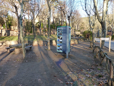
Leave Solsona from the starting point on the riverbank and follow the River Negre until just past the Corb Spring. Take a path that climbs up on the left-hand side until the Creu Blanca area and then follow the tarmac track that heads off to the right. It is possible to enjoy beautiful views of El Castellvell (the Old Castle) de Solsona as you walk along this part of the route. A few metres further on, turn off to the left and follow the path that runs down to the Mare de la Font Park. Once there, it is possible to visit the botanical route which is the starting point for the trail that leads to the La Mina (Mine) spring. At the spring, follow a small path that climbs up to the left and make for the C-26 highway. Take the tarmac track that goes off to the right and which leads to the La Cabana del Ton (Ton’s Cabin) farmhouse; having passed by it, you will then come to the path that climbs up to El Castellvell.
From here, you should head downhill to the urban nucleus of Solsona. Following the signpost, you will then come to the C-149a highway. Follow this road for about 400 metres and then turn left towards the service area where you will find a path that will take you to the Plaça de Sant Jordi square. Continue along the itinerary, skirting the old road to Torà, until you reach the Cal Llarg housing estate; from there, it is possible to continue on as far as the Chapel of Sant Bernat. Following the signs, you will leave this part of the town and should then follow a track that leads northward, until you reach the Ribalta Gully. Follow the gully as far as the treatment plant and then take a tarmac track that heads off to your right. Continue along this road until it comes to an end.
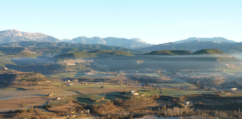
You will now have an even better view of the magnificent sierras of Querol, El Verd and Ensija, and may even catch a glimpse of the mountain El Pedraforca and the Cadí Sierra behind them. Turn to the left and head down the tarmac road until, having past Cal Pubill, you come across a track to your right. Continue on to the end of that track, crossing the main road (the C-149) via a bridge, and then head off to the right until you reach the road to Manresa. Cross that road and take the path that leads down behind premises belonging to a construction company. Follow this path into an area of crop fields in the northern part of El Vinyet. Cross the Moriscots ditch and then turn to the left after Cal Ramon. Follow the track until you come to the Chapel of Sant Honorat; at the chapel, take the path that leads downhill, which will take you to the cemetery of Solsona. Now cross the road and head up to the left until you reach the path that coincides with the Sant Bartomeu route. Follow it across the LV-4241b until you reach the starting point.
The Riner Tower
Begin at the starting point on the riverbank and follow the River Negre in a south-easterly direction. Go past the treatment plant and then, at the next turning, head off to the right, following the course of the river. Go past the house at Cal Sastre but then turn back towards the river bank, crossing the river a couple of times. The path constantly changes direction but never loses sight of the River Negre until after Casa Teixidor. When you are there, cross the river for the final time and go up a tarmac track that leads to the Torre de Riner (Riner Tower), which is close by.
Once at the tower, you will see that it is possible to climb up it. Both the Riner Tower and the parish church of Sant Martí offer excellent vantage points that look out over the valley of the River Negre and the Estany Ditch.
The Ribalta Torrent
As suggested by its name, this itinerary follows the course of the Torrent (rushing stream) de Ribalta. The route is flat and does not present any technical difficulties, with footbridges and tunnels facilitating movement through the area.
Begin at the starting point on the riverbank and follow the right-hand bank of the River Negre heading in a south-easterly direction. While still within the built-up area, cross the river and continue along its left bank. You will then come to a wide track, which you should follow as far as the treatment plant. This final section of the route, which is known as the Camí de la Ribera (Riverbank Path), is very popular amongst walkers from Solsona.
The proximity to the River Negre throughout the itinerary allows walkers to discover points of significant ecological interest, such as the riverbank woods (which include a recently established ash plantation) and some quite unique examples of willow trees. It is also possible to observe fauna or, at least, to detect signs of its presence.
This route is particularly recommendable for older walkers and families and is very agreeable during hot periods as it is protected by the shade of large trees.
The Afrau Bridge
Leave Solsona heading in the direction of the Cabana del Geli (Geli’s Cabib) housing estate. The first section of the itinerary runs along the banks of the River Negre, but the route subsequently leaves the river and crosses the Rasa de Cirera (Cirera Ditch). Then, take the left-hand path and continue along the right bank of the ditch until you reach the Pont de l’Afrau (Arfau Bridge). Most of this section of the walk lies in the shade of poplar, willow and ash trees. The Afrau Bridge is a monumental aqueduct which is 60 metres high and 60 metres long and dates from the middle of the 18th century; it used to carry water from Lladurs to Solsona.
The return route passes through the wood and later follows a tarmac track that runs down to the Creu Blanca housing estate and then on to Solsona.
This itinerary is suitable for walkers of all ages and is particularly recommendable for hot days. It offers the possibility of seeing fauna and well-conserved riverside woodland.
The Brics Pools: L'Alzina – The Miracle Shrine
Start from the Sant Jordi roundabout (next to the lorry car park) and follow the path as far as the Barranc de Ribalta (Ribalta Gully). Continue along the gully, heading westwards, following the signposts. Once you have gone under the main road, cross the gully and follow the path southwards, guided by the red and white marks that identify GR-7.
Cross another gully and, after first crossing the C-451, then cross the Torrent d’Aigüesvives. This area is of particular interest because of the stream that emerges here and flows as far as a stand of pine that was regenerated following the forest fire of 1998.
Then follow the road south to Brics. Before arriving there, you must go down a path that will take you to the Basses de Brics (Brics Pools). Then continue along the path, heading towards the south-east. The route initially climbs up through woodland and then drops down to L’Alzina. You will then pass through a farmstead but should continue along the path until you reach the pool that has the same name as the house.
The two pools are significant in size. They have been specially prepared to allow people to observe the fauna that live there and there are special vantage points for observing animals (without being seen by them) and also information panels that explain the natural value of the two areas: Brics and L’Alzina.
The route then continues on to El Miracle, which is 4 km and approximately 1 hour’s walk away. This part of the itinerary is signposted with markings indicating the GR.
The Santuari del Miracle (Miracle Shrine) is an area of great cultural and architectonic interest. It has several quite unique elements, including a baroque style altarpiece and its organ and square. This is a monumental group of great relevance which hosts liturgical and spiritual activities. The area is located at a point that offers interesting panoramic views of much of the comarca (local district).
Mare de la Font - Castellvell
Set off from the starting point on the riverbank and follow the Barranc de Pallarès as far as the Mare de la Font (Virgin of the Spring) Park. This stretch of the itinerary is of great ecological and scenic interest; it is accessible to all types of visitor and is also suitable for cyclists.
Before reaching the restaurant, go up the steps to the tarmac road, cross the road, and go to the information point, which offers information about the protected natural spaces of El Solsonès. Go through the metal tunnel and take the path that follows the botanic itinerary.
Pass the Font d’en Manel (Manel’s Spring) and head on to the Font de la Mina (the Mine Spring). This spring can be found next to a cave (from which water springs from the ditch in the form of a waterfall and flows to a small pool). On the other side of the spring, at a certain height, is the entrance to the mine that gives its name to both the park and the spring. Go up to the top of the stairs and the sports circuit of the La Mina Park. Head in the opposite direction to the C-26 highway and into the wood, following a path that starts to the right of the park. Follow this path through the wood, skirting the castle, and gradually climb up to the exit that leads to the road that goes on to El Castellvell (the Old Castle).
Follow this road all the way up to the top. El Castellvell and its gardened surroundings offer an imposing vantage point from which to observe the local territory. Begin the walk downhill following a path that soon becomes a set of wide stone stairs that descend in zigzag fashion. On the way down, it is possible to enjoy panoramic views of the municipalities of Solsona corresponding to the areas of Olius and Lladurs. Before reaching the end of the route, you will pass an old road that is documented as “a path bordered by walls that originated from a farmhouse or from the town”.
Sant Esteve d'Olius
Set out from the starting point on the riverbank and go along the right-hand side of the River Negre. At the first marker post, turn towards Carrer de la Bòfia and then follow Carrer del Drac, crossing the road to Sant Llorenç de Morunys and heading towards the cemetery.
Once there, and without crossing the main road, the itinerary continues along the north-west side of the cemetery, following a path that runs downhill in a north-easterly direction and which will take you to the Chapel of Sant Honorat. When you subsequently meet the same road again, follow its right-hand side until you come to the crossroads. The path to the left goes to the Masia el Cavall farmhouse, but you should follow the sign and go to the right, following the GR marker. First pass the Plains of Olius and then, further on, you will pass some woods on the left-hand riverbank. You will soon find yourself in the middle of a wood. Follow the GR along a path that has large blocks of stone and cross it to reach the main road that will take you to Sant Esteve d’Olius.
This architectural set includes a cemetery and a Romanesque-style church. The Art Nouveau style cemetery of Olius was designed by Bernardí Martorell i Puig, a disciple of Gaudí. The church has a crypt of significant value and is very well conserved.
Near this place of worship, it is also possible to visit a number of Iber silos that were restored a few years ago (these were “pantries” dug out of the ground for storing food, and particularly grain).
The final point on the route is of great natural, cultural and architectural interest. The settlement of Olius is located just a few metres from the course of the River Cardener, a space that is of ecological interest, on account of its good state of conservation, as a fluvial ecosystem (here, it is possible to observe fauna and flora typical of riverside habitats).
Sant Bartomeu
Begin at the starting point on the riverbank and then cross the LV-4241b (leaving behind the Cabana del Geli housing estate) and look for a path, on your left, that follows a narrow alley with stairs. If you carry on ahead, you will go towards the Sierra of Sant Bartomeu.
A few metres from the beginning of the path, you will go along a Camí Ral (medieval road), which is constantly bordered by crop fields that form the characteristic mosaic of this area. Further on, at the foot of the sierra, take a path that climbs steeply up the left-hand side of Mas Vent Serè. When you reach the top, go through a small wood and, on emerging from it, go on for a few metres more until you find a track with stairs, on your left. Go up these stairs and then continue along the path until you reach the top of the hill. You will slowly discover interesting panoramic views of the municipal area of Solsona and the southern part of the comarca (local district). At the top of the sierra, you will find the Cova (Cave) de Sant Bartomeu, which is a small cavity in the earth surrounded by very large blocks of stone.
Start the descent along a path that emerges from the highest point of the summit, behind the cave. Cross a wood until you reach a forest track. Leave this track to follow another path that runs down to the left until you come to a meadow. Skirt round the meadow and follow the path downhill until you find a tarmac track. Follow this track and cross the car park of the Centre Tecnològic Forestal de Catalunya (CTFC). Then follow the road on the left until you find the path along which you started the route. Follow it back to the starting point.
Distances and times required for the different routes:
Pont de l’Afrau: 7.7 km – 2 h
Basses de Brichs i l’Alsina: 7.6 km – 2 h
Mare de la Font i Castellvell: 4.9 km – 1h 20 min
Sant Esteve d’Olius: 5 km – 1 h 10 min
Torre de Riner: 10 km – 2 h 25 min
Sant Bartomeu: 6.5 km – 1 h 45 min
Torrent Ribalta: 3.8 km – 55 min
Volta al Vinyet: 17 km – 4 h 10 min
More information: Oficina de Turisme del Solsonès i Solsona
Pictures