La Porta del Cel
A CROSSING THAT GOES BEYOND COMPETITION!
This circuit, with such an eye-catching name, will take trekkers right up into the sky as they climb the Pica d’Estats, the highest mountain in Catalonia (Spain), and on the way there, they will also climb the equally impressive peak Certascan peak. The colours seen reflected in the lakes that they will pass along the way are reflections of the sky and each lake or pool seems to reflect its own particular shade of blue. From the impressive Certascan pool, which is the largest natural lake in the Pyrenees (Spain), the route leads on via the Sotllo, Pinet, Blaus and Romedos pools to take trekkers to a series of ever more beautiful natural settings. This is a special circuit that neither recognises nor is confined by man-made frontiers. It runs through areas of natural beauty on both sides of the Pyrenees; crossing the French Ariège and the north of Catalonia.
THE CIRCUIT
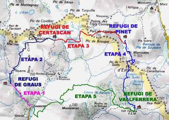
The circuit takes in 4 mountain shelters, those at Certascan, Pinet, Vallferrera and at the campsite in Graus, as well as taking trekkers to the village of Tavascan and through both the new, Alt Pirineu (High Pyrenees) Natural Park and the French territory of Ariège. There are only 4 mountain shelters along the route, which means that it is necessary to complete the walk in a maximum of 5 days, unless trekkers wish to take their rucksacks and carry food and camping equipment with them. Although the stages are quite long, carrying a light backpack and with a little physical preparation, it should be possible for most walkers to complete the route without any problems. The places through which the circuit passes are breathtakingly wild and of undoubted beauty. They include such emblematic locations as the Certascan peak, the Pica d’Estats – which, at 3143 m, is the highest summit in Catalonia - the Artiga valley and Pinet mountain shelter, the Pla de Boet (Boet plain), the Bordes de Noarre and Bordes de Graus (rural outposts), the village of Tavascan, the Blaus, Romedo, Estats and Sotllo pools, and lake Certascan, which is the largest natural lake in the Pyrenees. Following the circuit, walkers will discover many of the attractions of the local territory, although it should also be stressed that the proposed route still leaves aside other interesting peaks and lakes. These could perhaps be discovered on a longer stay or later visit that would allow trekkers to get to know the area in greater detail.
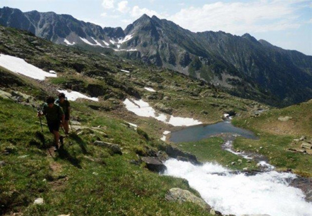
1. From Tavascan to Graus
Variation in altitude: +290 m, -50 m.
Distance: 4.2 km.
Time required 1.30 h.
This first mini-stage serves as an appetiser. It has been kept short in order to avoid having to make the other stages excessively long.
Walkers arriving after a previous journey will find it relaxing to enjoy a leisurely stroll through the village of Tavascan, which still remains relatively unaffected by the impact of tourism. The church and Romanesque bridge and the stone houses with their slate roofs still maintain the same appearance that they have had for centuries. After the trip to Tavascan and a little sightseeing, there is nothing better than a good meal to prepare for the mountain crossing.
Walkers will follow an old mountain path that is simply full of history and which used to be used by the inhabitants of the village when they went up the mountain to cut grass or tend to their livestock. In fact, in the past, some people only went down to the village in winter when the snow forced them to abandon their bordes (rural outposts associated with agricultural activities in otherwise unpopulated areas) in Graus and Noarre. The route was also well-known to the smugglers who used to follow the path from Port de Tavascan to France, where they would stock up with the sacks of flour that they needed to survive.
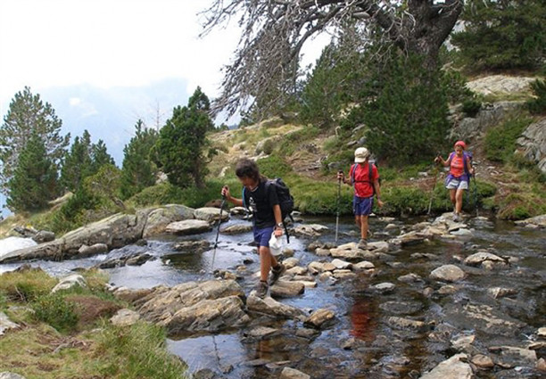
The path smoothly climbs the mountainside, following the river Tavascan, that will first appear to their left, but which walkers will then cross twice before arriving at an area of open pastures, before finally reaching the mountain shelter at Graus, which is to be found at the local camp site.
2. From the Graus mountain shelter to Certascan, via the Certascan peak
Variation in altitude: +1500, -620 m.
Distance: 12.5 km.
Time required 6.20 h.
Without going to the summit 5.15 h.
The route then assumes the characteristics that will typify it throughout the rest of the crossing. Although this is the stage that includes the greatest ascent, it is not the hardest, as this climb is compensated by the short descent.
The route climbs high above the Graus reservoir and continues on in the direction of the river Noarre. The climb becomes straighter at this point, but it still remains relatively comfortable until the rural outposts of Noarre. These country dwellings, which can only be reached on foot, are still relatively very well conserved, although now there is only one person living there; a man called Jaques. The other rural outposts, which are almost always unoccupied, are now only used as second residences.
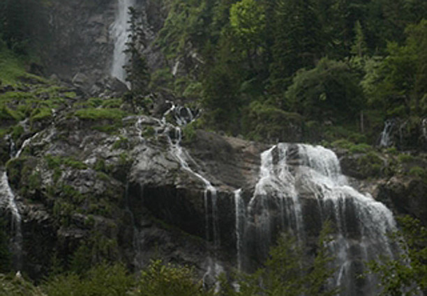
The path then continues its gentle climb up the hillside, first passing through meadows before reaching a waterfall. At this point, it turns and zigzags through a wood and on to the Pleta de Guerosso. This attractive animal enclosure occupies the site of a former lake that was covered by sediments. From this point on, the path then becomes more rugged as it follows the river to the lower part of the Blau pool. There are then another 3 pools, which can also be visited by trekkers who have sufficient time and stamina, but the main path does not pass next to them.
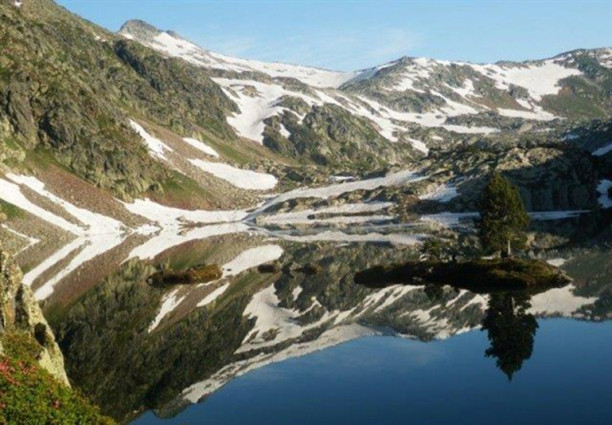
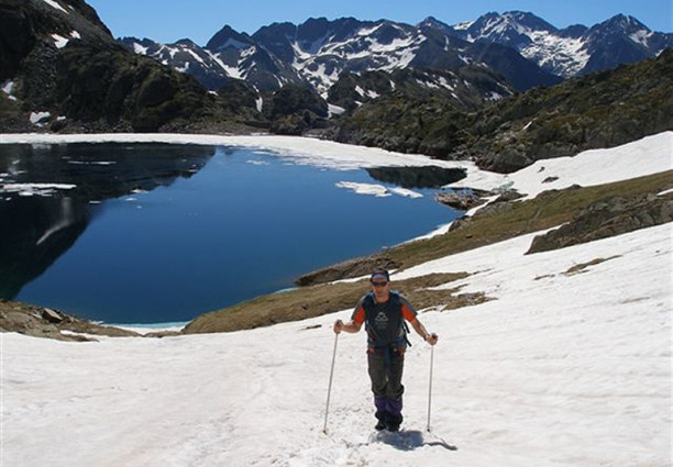
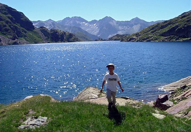
Once at the col of Certascan, there is the possibility of going directly to the mountain shelter, but the main route follows the scree to the 2853 m summit of Certascan. From the top of this peak, it is possible to enjoy one of the best panoramic views in the Pyrenees (Spain). It is then just a case of heading down the mountain to the shelter where, depending on the time of year, there may still be a little snow. The route then passes lake Certascan which, at 1200 metres long, 600 m wide and 102 m deep, is the largest natural lake in the Pyrenees (Spain). This lake is truly impressive with its cobalt-blue colour and with its surrounding mountains of red schist and white granites.
3. From the Certascan mountain shelter to Pinet
Variation in altitude: +- 1350 m.
Distance: 13 km.
Time required 7.45 h.
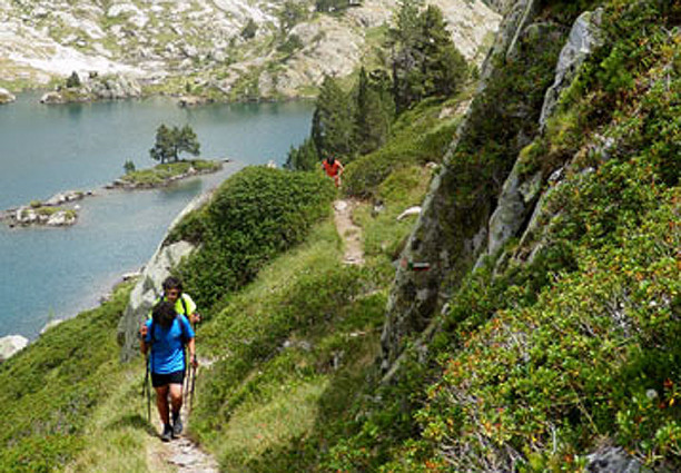
From the mountain shelter trekkers will join a trail with 35 curves that will take them to the col of Llurri, from where it is possible to look out upon the truly magnificent sight of the Romedo de Dalt pool with its islet and lonely pine trees. But unless visitors have plenty of time to walk around the lake, they should continue on along the trail and down to Romedo de Baix.
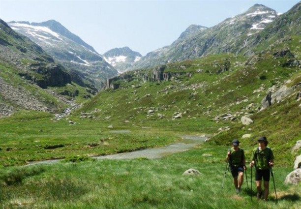
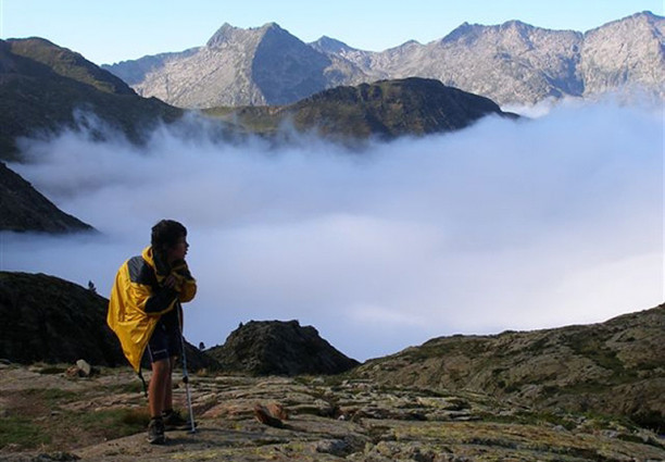
There are then two more lakes with crystal-clear waters, followed by quite a straight section of the route as far as Port de l’Artiga. From this point, trekkers can look out into the depths of the Artiga valley, in what is perhaps one of the least known parts of the French Pyrenees; Ariège.
The scree will then guide trekkers to an area full of meadows and the path leaves this valley to follow a narrow river gorge down to the Montestaure pool. The dark countryside and several straight climbs will then take walkers to the secondary peak of El Recós, from where it is possible to see the final destination on this stage of the circuit; the Pinet mountain shelter, although this still lies further away than what it might seem. Trekkers will then find walking sticks useful on the climb down the mountainside and as they negotiate the Picou de l’Estela col. The route then passes below a spur that obstructs a more direct route. It is then a case of climbing up above the height of the mountain shelter in order to find a place at which to cross the deep-flowing waters of the river Barz, which has few crossing points. Having crossed the river, a chain will help walkers to overcome a minor obstacle and find their way down to the pool and the mountain shelter of Pinet.
4. From the Pinet mountain shelter to Vallferrera, via the 3143 m Pica d’Estats
Variation in altitude: +1100, -1400m.
Distance: 13.3 km.
Time required 7.15 h.
Without climbing to the summit 5.45 h.
Curiously, what for many might seem the most important stage of the circuit is, in fact, the shortest and most comfortable (with the exception of the 1st stage), as the paths are better marked and easier to follow.
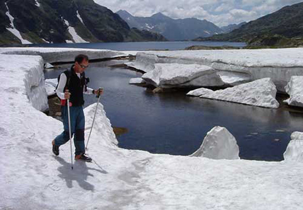
The French side of the slope is very dark and closed by the imposing walls of rock that separate it from Catalonia (Spain). Trekkers must therefore follow the river Barz as far as the Estats pool and then on to the Montcalm pool. The route is always surrounded by rocky scenery and mineral deposits. Another small pool, which is almost always frozen, leads to a col, from which it is possible, for those who have walked far enough and are tired, to descend directly to the Vallferrera mountain shelter. This is also an interesting option in the case of bad weather. But otherwise, the circuit continues on to the Coll de Riufred and the Pica d’Estats. In fact, those with plenty of energy to spare may even wish to climb all of the three thousand metre peaks along the trail, including Montcalm and Sotllo. Whatever the case, it is important to remember to save some strength for the following day.
From the Pica d’Estats, trekkers will continue on to the Port de Sotllo, where, depending on the season, they may find a small glacier which is best crossed with the aid of crampons. From this pass, there is a long and rather uncomfortable scree descent to the Estats and Sotllo pools.When it is not possible to cross the gulley, trekkers should follow the foot of the mountains through the catkins of Areste and to the mountain shelter.
5. From the Vallferrera mountain shelter to Tavascan
Variation in altitude: +1315, -2100 m.
Distance: 20.3 km.
Time required 9.30 h. (Via Boavi 8 h.)
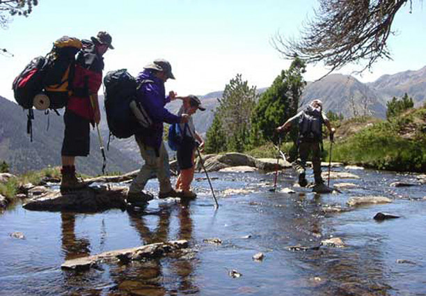
This is the longest stage and also the one with the greatest descent in altitude in the whole route. Those who feel tired or who do not think that they have enough stamina to reach Tavascan, by the programmed route can walk down the Sellente valley to Boavi and then follow the track to Tavascan.The main route follows the river Vallferrera through a thick forest, retracing the path to Rebuira, until it reaches the Baborte gully, where it then begins to climb once more. The route passes various pools and the mountain shelter before reaching the Sellente col, where it continues its descent to the Becero pool. From here, an old and half-forgotten herders’ path, which has hardly been used for tens of years, runs past cattle enclosures whose water supplies have now run dry, and skirts the whole of the mountain, before finally arriving at Ribera de Boldís. The panoramic view and the footpath that follows the edge of the wood are both impressive, but so too is the length of the trail, which can lead walkers to forget the delightful countryside.The trail leads down from the shelter in a series of short descents, but with the general tendency being for it to skirt the seemingly never-ending mountains and woods, from which it is possible to see the villages of Aineto and Tavascan. The route finally reaches the demolished huts of Planes, where there is a complete change of direction as it follows the GR along a path that then heads down the mountainside and to the village of Tavascan.
Variant 5.1. From the mountain shelter of Vallferrera to Àreu
Variation in altitude: +100, -800 m.
Distance 11 km.
Time required: 2.35 h.
The variant via Àreu is divided into two stages and always follows GR 11, which is a very well-signposted route. This first option is a very comfortable and gentle route and will allow walkers to rest a little after all of the effort of the previous days.The early part of the route is quite breathtaking, with the path passing through a magnificent forest of fir trees. The trail then follows a very flat trajectory along the track. Further down, the forest becomes more varied with pine and birch trees and the route then follows the track for another 5 km and to the village of Àreu.
Variant 5.2. From Àreu to Tavascan via the col of Tudela
Variation in altitude: +980, -1090 m.
Distance 20 km.
Time required: 6.15 h.
Many sections of the route now follow the track and it therefore loses much of its attractiveness: this is, therefore, the most monotonous and least alpine part of the whole route.The route then climbs upwards along the track as far as the rural outposts of Costuix and from there it follows a very straight path that rises up through a magnificent pine forest. This takes trekkers to the col of Tudela, from where the path leads downhill once more, again joining the track. The stretch from here to the village is probably one of the dullest. The path crosses through the middle of the village of Boldís Sobirà and then once again skirts the hills as it follows an age-old footpath as far as the final descent to the village of Tavascan.
For more information: La Porta del Cel
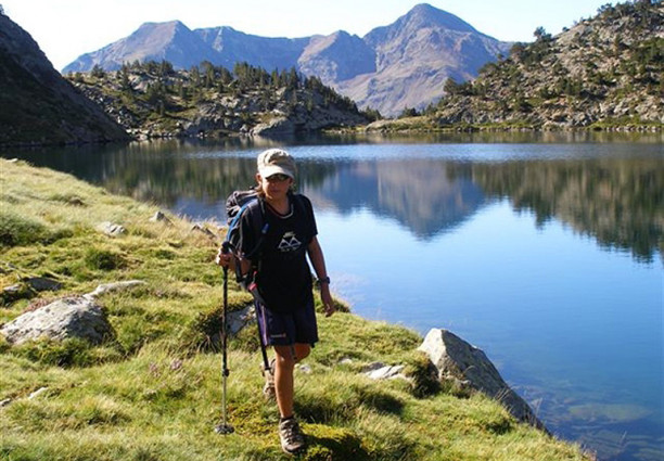
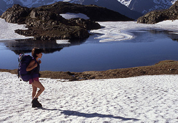
Pictures